GPS methods
Since the advent of GPS, several different flight test techniques have been developed to make use of this system in determining pressure errors. There are good reasons why GPS is attractive for such tests:
• No special equipment is needed, such as trailing cones, kinetheodolites, cameras.
• There is no need to keep and maintain a calibrated pacer aircraft.
• A surveyed ground course is not required.
• Flying close to the ground is not required.
• There is no requirement for radar tracking.
The largest drawback to these methods is that results typically show high data scatter. The paragraphs below outline two multi-track GPS techniques that have been developed.
7.3.6.1 NTPS method
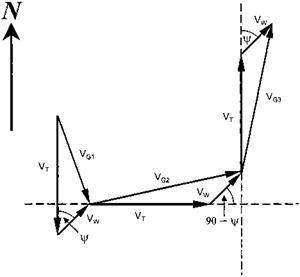
In this method, three orthogonal headings are flown at the same IAS and altitude (see Fig. 7.3). The ground speed is read about 15 to 20 seconds after the IAS is stable,
|
Fig. 7.3 Flight path for PEC measurement using GPS (assuming constant wind strength and direction). |
allowing time for the GPS data to stabilize. From the three groundspeeds, the wind velocity, wind direction and true airspeed can be determined using basic trigonometry [7.7]. The resulting angle for the wind direction is the angle clockwise from north, assuming that the original heading was south. For other initial headings, the wind angle must be adjusted. Knowledge of wind direction and velocity is not strictly necessary to determine the PEC as they can be eliminated from the equations. However, a review of the wind data might prove useful in determining if the test data is reasonable.


